Wednesday, October 22, 2014

September 2014 in Sedona

Elaine & I stayed at Arroyo Roble unit 1108 for two weeks starting September 19th Friday-to-Friday.  Weather was beautiful!  Elaine & I did Thunder Mountain, and I went up to the top for a view, while Elaine enjoyed shade down below.
Nancy Lunetta and Kay Coen visited, and Nancy and I did the hike to Seven Sacred Pools.  Here is a link to photo album:
Nancy & I at trailhead

At the "pools"


Nancy, Kay, and Elaine surprised me with a celebration of my 70th birthday a few weeks early.
On the 24th, I did the Ridge Trail by myself.  Here is link to photos  Elaine dropped me off at trail head along Chavez Ranch Rd, and then picked me up at Shelby  Rd.  Here is a link to National Forest Description

 Scenery along the trail was surprisingly good, and there were more flowers blooming in September than most areas had in April, because of the dry winter and wet "monsoon" season during the summer.

The next day, I explored the Javelina Trail, which is a relatively new trail that starts on W 89A just West of the Post Office.  Elaine dropped me off and picked me up at the Jordan Road trailhead.  Here's a link to photos
For being as close to civilization as it is, the trail seemed to be far from it.  Lots of forest and as I got up higher, there were some good views.


The next day I did what is becoming one of my favorite hikes -- Brin's Mesa with a North detour up to an overlook.  Views are always spectacular, and difficult to capture properly with photos.  However here is a link to my photos from that day.
 This is the view from a very high perch with sheer walls below
We brought along the 2 person rubber raft, so Elaine and Nancy did their "white water rafting" down the mighty Oak Creek in front of Arroyo Roble.  Weather was perfect, water was not too cold, and they had a really good time.  Link to photos & video.  Also during their short stay in Sedona, Nancy and I did the Marg's draw trail from Schnebly Hill Road trailhead, and Nancy took all of us out to brunch at Enchantment. 
 Nancy at the Marg's Draw trailhead
Nancy at Enchantment Resort

Due to the horrible forest fire in Oak Creek Canyon during June, all of the trails in the canyon were closed from June until the beginning of October.  Our son, Sean flew to Flagstaff, and then drove home with us after spending several fun days hiking the trails.  We were very pleased that they opened the West Fork trail before we left to go home.  It was clear that the firefighters had a very difficult time in that canyon, but they did manage to save most of it.  There were patches of forest where most of the trees were damaged or destroyed.  The West Fork was full of ash/mud at the many ford/crossings, which was somewhat ugly.  But other than that the trail was beautiful, as usual. 

When Sean arrived at Flagstaff Airport, we took him on a short tour of Flagstaff, including a hike in Buffalo Park, lunch at one of the many excellent brew pubs in Flagstaff.  
Sean at Buffalo Park
At Meadow at Oak Creek Canyon Overlook
Then the three of us did the short walk to Griffith Springs,  and a walk around the Oak Creek Canyon overlook at the top of the switchback. Here's link to photos


Sean & I did a hike to Submarine rock and Chicken Point, and Elaine picked us up at the Chapel. Link to album
Then we drove back Dry Creek Road and hiked to Devil's bridge --Link to Album , then drove to the Palatki archeological site, and took the docent tour of the ruins.

 Sean at Devil's Bridge
We were very pleased when they opened the West Fork Trail -- and we were among the first people to take the trail since it was closed in June. (Link to Album)


Sean Crossing the West Fork at about the 7th crossing--lots of ash in water

To wrap up our 2 weeks in Sedona, and Sean's 5 days, Elaine dropped us off at Red Rock Crossing and we hiked along the Creek and up to the top of Cathedral Rock.  Elaine picked us up at the Back 'O Beyond trailhead.  Pretty strenuous hike! Link To Album
 Sean out on a point up in the Cathedral Rock formation -- yeah, that's a sheer drop below him.
Sean on Ledge at near the top of Cathedral Rock


.  


Thursday, May 1, 2014

Sedona Hiking Information and Resources

There are a lot of excellent web sites and books that can help visitors find information about hikes.  Because there are so many trails and so much information available it makes it difficult to decide which trail to take. There are several different visitor centers in the Sedona area, and the rangers and docents are always very helpful.  The National Forest Visitor Center along route 179 just South of Village of Oak Creek has lots of good information.  The visitor center in "Uptown Sedona" next to the Hyatt timeshare is also an excellent spot to stop.
Here are some of the web sites:
  • William F. Palmer Professor Emeritus of Physics at The Ohio State University has this web site, which has a lot of the Sedona trails listed alphabetically along with a trail description, map and photos. 
  • Great Sedona Hikes by William Bohan, at this URL has a database of hikes with the ability to sort by difficulty and alphabetic. It also identifies ones near water, near vortexes etc. The site also has descriptions and maps of the trails 
  • The Hike House web site: www.hikehouse.com has trails as well as videos that could be helpful for someone trying to select a trail to explore. 
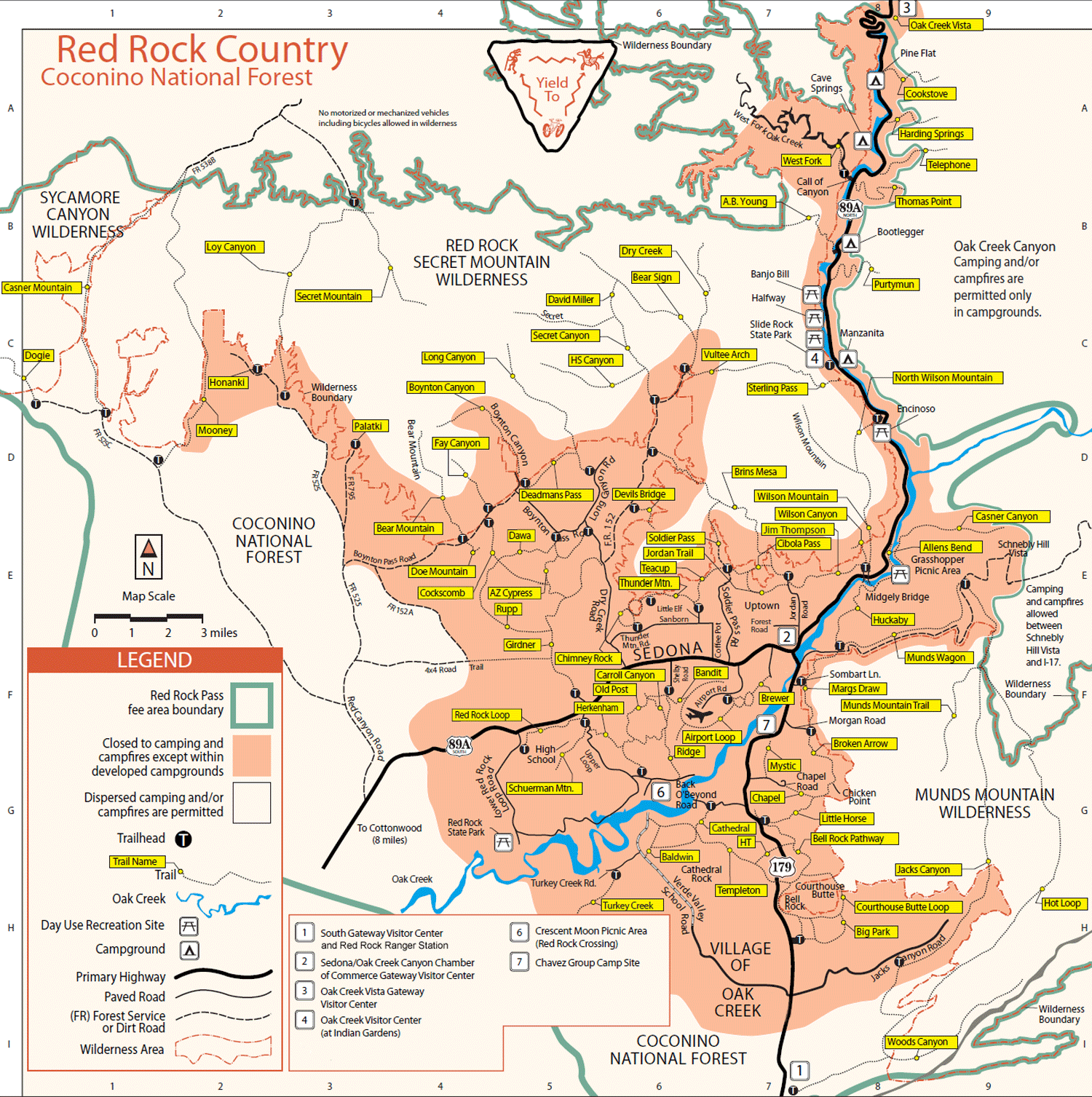
  • The Red Rock Country Map published by the Coconino National Forest provides an excellent overview of many of the trails in the area. I found a copy on this blog web site. The Forest service also has excellent descriptions and maps at this link, and you can choose between day hikes and overnight hikes 
  • This Blog: http://arizonahiking.blogspot.com/ has over 500 Arizona trails indexed. It was created by Mare Czinar, who writes a regular column (Including "hike of the week") for several Arizona newspapers. Her site has quite a few of the Sedona area trails, and seems to be more up-to-date than some of the others. For example, it includes "Adobe Jack" trailhead that was opened in 2012 along with the trails throughout that basin. 
There is also an application for iPhone or Android that specializes in Sedona Hikes an now has 74 trails cataloged.  It is called:  -- "Sedona Hiking App"  Apparently new hikes are added periodically, since I just received an email (from Jon Clayton info@sedonahikingapp.com ) that described Turkey Creek Trail as being added to the app.  


Saturday, April 26, 2014

April 2014 in Sedona

In April, we stayed in unit 1101 at Arroyo Roble, at the "upstream end" of Old Creekside.  Carol Pennell joined us for a few nights at the beginning of the 2 weeks.

On Friday,  Elaine dropped me off at the Airport Road Trailhead, and I did the loop around the airport mesa.  We have done the trail part way many times, but had never done the complete loop. Go to this link and open in Google Earth to see the trail:   Because of the dry winter & Spring, there were not many wildflowers -- a big disappointment!  However Friday night we had a good rainstorm, which brought snow to the higher elevations.  Hopefully the rain will bring out some more wildflowers.  Here are photos:


Elaine dropped me off at the Cocks Comb trailhead today. Trailhead is off Boynton Pass Road, just past the Doe Mountain trailhead.  Here's a link to Palmers Trail write-up.Here's Palmer's map and elevation chart.  He describes a simple round-trip to top of mesa and return.   Here's great Sedona Hikes description -- but it doesn't include a the trip to the top of the mesa.  Most of the trail was flat and very bicycle friendly. However I followed the trail advice by "Cosmic Ray" trail guide and climbed up to the top of the Cocks Comb mesa. Spectacular View! Here is a link to the "track" that will open with Google Earth. Note from the well marked and maintained trail, there is NO marking for the turnoff to go to the top of the mesa.  In fact, there was a log across the trail, as if someone didn't want us to take the trail.  However the trail can be easily seen on the right side as you pass by homes being built on the left side of the trail.  Below are the photos I took on the trail:


Elaine and I hiked Marg's Draw Trail from Schnebly Road past Snoopy Rock.  We met other hikers that had us take a photo of them -- and they took a couple of us as well.  We met "Reno" on the trail too--a retired cardiologist who was a member of Sedona Hiking Club for many years.


On Friday, while making coffee, I saw a large herd of Javelinas run by the window, so I went upstairs, grabbed the camera and took these photos from the back balcony:

Then,  Elaine dropped me off at the Yavapai Vista trailhead.  It is at the last overlook heading South on 179 before you get to Village of Oak Creek.  Our friend Barbara Glass recommended the trails at that location.  I took the Yavapai Vista trail to the HiLine trail and ended up at Cathedral Rock and came down the relatively steep trail to the trailhead parking lot where Elaine picked me up.  The views were spectacular!  Here is a link to the trail write-up by Great Sedona Hikes, and here is another write-up by Palmer


On Saturday morning Elaine dropped me off at the Centennial Trail area on Cultural Park Place, near the High School and Community College, and then picked me up in the Color Cove Street neighborhood off Dry Creek Road.


On our last Spring 2014 day in Sedona, Elaine dropped me of at the Schnebly Road trailhead and hiked up the Mund's wagon trail to where the Hangover trail and then hiked up hangover to where it connected with Cowpies and then returned via the Munds wagon.  While at the top of the hill on Hangover, I lost the trail!  I met a hiker named Stephanie who had been on the trail several times.  She  led me around the North side of the mountain on the trail until it met up with cow pies.  She then went on up to Merry-go-Round overlook, and I returned to the trailhead via Munds Wagon.  Here's a link to the "My Tracks" that, when opened with Google Earth, it shows the whole route I took:  8.88 Mile loop.  Here is link to trail description, and a link to the map in the area: http://www.physics.ohio-state.edu/~palmer/SedonaTrails/Bear's%20Hangover/Hangover.JPG
Below are my photos from the trip:

Monday, September 23, 2013

September 2013 -A green Fall in Sedona

We went to Sedona for 2 weeks starting on September 18th and stayed at Arroyo Roble unit 1102. On the way to Sedona we noticed that everything looked much greener in the desert than any other fall trip to Arizona.  The "monsoon" rain storms they had during the previous month really helped the plants.

Our Sunnyvale friends, Nancy Lunetta and Kay Coen came for a few nights, and Phoenix friends Nancy Rieckhoff and Mark Mann came for Friday and Saturday night.  Elaine and the three ladies found lots of bargains, and Mark and I did a few fun hikes.

My first hike was up Wilson Canyon -- the trail starting at Midgley Bridge which is just a few miles up Route 179 from our timeshare. (Link to Trail Description)  Elaine and I had done the hike before part way.  Then a few years later,  Bill and I did it all the way to the top.  This time there seemed to be more water in the creek (that you have to criss-cross back and forth over.  I was surprised to see that someone had placed a "trails end" sign at a nondescript location, very close to the spot that is the attraction at the end.  I have the impression that the Forest Service, or trail builders want everyone to stop.  However why would we stop there when there is such a wonderful view of spires and back the canyon just up a short hill?  I think they need to extend the "official trail" up to the first hill and then put "end of trail sign" there.  Because there is no "official trail" -- everyone makes their own and causes considerable damage, wear & tear on the environment.  There were also a surprising amount of wildflowers for a fall hike.  Here are some photos

Here is a .kml file that you can download and open using Google Earth.  If you then go to maximum magnification you will be able to simulate a "personal drone" tracking my path along the trail  It was my first attempt at using "My Tracks" and I started when I left the timeshare and drove to the trailhead.

The next day while Elaine went to garage sales with Nancy Lunetta and Kay Coen, I drove up Oak Creek Canyon a little further --almost to Slide Rock State Park, near the Manzanita Campground, and parked near the trailhead for Sterling Pass.  I hiked up through Sterling Pass, and back down the other side to Vultee Arch.  Then, of course I had to hike back up through the pass again and back to the trailhead.  It was quite a climb.  A lot of the pass trail was on the North side of ridges, and were cooler and wetter.  There were a lot of different wildflowers.  Here are some photos from the hike:


Here, again, is a .kml file that you can open with Google Earth and track every step of my hike as if you were in a personal drone overhead.

Here are some photos from Nancy & Kay's short visit:


Mark Mann and I hiked a little bit of the Sedona Airport Trail (Hike Description),  the Airport Vortex hill,  and then hiked the Soldier's Pass trail past Devil's Kitchen, the Seven Sacred Pools (all had water), up to the rim of Brinn's Mesa and then returned.  The next day we went to Clarkville with them (to an importer from Indonesia) and then to Red Rock Crossing.  Here are some photos from their visit:


On Monday, Elaine dropped me off at the Doe Mountain trailhead parking lot, and I crossed the road to the Bear Mountain Trail -- one of the highest peaks in the area (Link to Description).  Here are photos from that hike:


Here is the Google Earth kml file to take the virtual hike.  Note I forgot to stop the "recording" until after Elaine picked me up and we had driven a little bit -- so no, I didn't hike at 45 mph.

While on the Sterling Pass hike, I met a group of hikers that told me that everytime they visit Sedona they take the "Little Horse" trail from the Chapel--and thought it was one of the highlights of their visit.  I looked it up and the trail that starts at the Chapel is "The Chapel" trail --but it connects to the Little Horse Trail. (Here's another description) So Elaine and I did hike the Chapel trail...and it was very beautiful.  Good views looking towards Cathedral Rock, Views south to Bell Rock and Courthouse Butte, and views looking up at the amazing rock formations.  I thought it was labeled an "easy" hike, but after we completed it I found out that other sites call it a moderate difficulty hike.  Not much overall climb--but lots of up & down.
Here are our photos:


Cathedral Rock Climb to the Top I had always heard there was a way to hike to the top of Cathedral Rock, (link to map) but had never explored that option.  On previous trips we took the trail from the trailhead off "Back 'O Beyond" down to Red Rock Crossing, and saw the trail to the top of Cathedral Rock --but never had the time to do it.  This time I went up on a beautiful day, took my time, plenty of water and snacks and really enjoyed the hike and the views.  A Japanese guy went up the trail when I went up and he was carrying a case with a lute.  He sat and played up at the top and his music echoed off all of the spires. The music seemed to come from everywhere.
Here are some photos:


Brins Mesa Overlook Trail  Elaine dropped me off at the Jordan Road trailhead  (map) and I hiked to the rim of the mesa.  I then took a little used trail to the top of the ridge on the South side of the mesa.  From the top of that ridge I could see all of Sedona, and look down on Soldier's pass trail.  I could see jeeps parked at the "7 Sacred Pools" location.  There was no clear trail marking, so I did get a little lost.  Fortunately, I had the "my tracks" app running (see this track on Google Earth)  and I was able to see that I wasn't going down the mountain the same way I came up --and was able to recover the trail.  Then after coming down from that ridge, I went to the overlook on the North side that Bill helped me find several years ago.  It was an easy walk across the broad mesa winding through the juniper trees.  After I got to the overlook, I also explored a couple of alcoves down below.   They were difficult to get to--and were big holes -- but nothing really special.  The view from the top, however was fabulous!

Here are my photos from the trail


Little Horse Trail  Elaine and I hiked the little horse trail --from the trailhead along rt 179. (Link to kml trail file)  Was a fairly easy hike --when walking, however there were quite a few trail bike riders on the trail.  It looked to us that it would be a little challenging for bikes --but certainly a fun ride.

Here are our photos


Wilson Mountain Trail
Elaine dropped me off at the Encinoso Picnic area, which was the trailhead for the "North" trail to Wilson Mountain.  I ended up hiking about 11 miles and up and down about 2000 ft in elevation and went to the Sedona overlook and the Brin's Canyon overlook.  (Here's link to the kml file that can be viewed on google maps or Google Earth ) I came down the "Southern" trail and met Elaine at Midgley Bridge.  Here are photos:

Friday, April 26, 2013

April 2013 -- Spring in Sedona

Spring 2013 we came to Sedona from April 15-29 (Monday to Monday) and stayed in Arroyo Roble unit 1113. We left home a day early and spent a night in Prescott, a route we had not taken for several years.  We were amazed at the continued growth of the Prescott area.  We stayed at a very nice Hampton Inn, and did a couple of short hikes in the area.  We were also impressed with their efforts to build a first-class trail system.  Here's link to their trails map.  Here's a link to photos from our day in Prescott:   Photos of Prescott Trails

Elaine on bench along the Prescott Lakes Trail


The first couple of days in Sedona were relatively cool.  In fact on the second day, we had snow flurries.  The snow flurries almost looked like the cottonwood that continually falls this time of year.   The rest of the two weeks had weather perfect for hiking in the morning, and going for a swim in the afternoon. We had no guests stay with us, for a change, so it seemed very quiet.  Elaine and I did a few hikes, and I did a few others where Elaine dropped me off, and I had the luxury of "one way" hiking.

Teacup Trail

My first hike by myself was the Teacup Trail. (Link to Professional Description) Here's link to photos from the Teacup trail. .  In general, it goes around the base of Coffee Pot Rock, and was pretty easy, but beautiful.  There were bicycles on the trail, but would be too tough for me to do --even on a really good trail bike. .
The beginning of the trail -- no markings other than the street intersection

A good view of Coffee Pot rock from the trail

Elaine and I  went to the V-Bar-V Heritage site (Link to the web site) on the East side of I-17 at the Sedona route 179 exit.  Here's a link to those photos.    The petroglyphs were the best I've seen, and the excellent docents there provided interesting explanations and theories about what the petroglyphs meant.
V-Bar-V Petroglyph area and Docent

 On our wayback from the V-Bar-V, we wen to lunch at Mongo's --a new Mongolian Barbecue place in Village of Oak Creek.

Carroll Canyon Trail

On "Garage Sale Saturday" Elaine dropped me off at the Carroll Canyon trailhead at the West end of Sedona below the High School, and I hiked up to the town and connected with the "Old Post" trail. (Reverse of this trail description link)  I looked for the Arch shown on the map, but couldn't find it.  I may have gotten confused by multiple "unofficial" trails.  Met Elaine at the park after the sales. Here's link to photos from that hike 
Looking up from bottom of Carroll Canyon


Elaine and I did the Andante Trail (Link to Map) from the trailhead to the Stupa.  It was an easy trail since we were rehabilitating Elaine's knee.  Beautiful day & great scenery..  See my photos
View North along Andante Trail

 For lunch we went to Tortas del Fuego,  a new small Mexican restaurant across from the Red Planet restaurant.  We tried their wet carne asada burrito, and their chicken tostada -- both were huge, and delicious!  The small restaurant is very crowded, and the place has almost no parking.  People park next door, and across the street.  

Marg's Draw Trail

View along Marg's Draw Trail

Elaine dropped me off at the Marg's Draw trailhead -- behind the Circle K on Rt 179, and I hiked the trail under "Snoopy Rock" over to Schnebley Hill Road trailhead. It is only 5 minutes from our timeshare.  Here's link to trail description.  From there, I looked for a way to get down to Oak Creek where I could cross over to our timeshare at Arroyo Roble.  There were several good trails -- but they ended up dead end on posted property.  I finally found what appeared to be an abandoned trail--heavily overgrown, and eroded in places.  Was able to get down to creek and cross on a log where Elaine was reading by the creek. Here's a link to photo Album 
Sign where trail from Circle K trail head meets the main Marg's Draw trail

Broken Arrow Trail to Submarine Rock

On Thursday, Elaine and I hiked the Broken-Arrow trail to Submarine Rock. Here's a link to the trail description.
That is Submarine Rock in background --on left side

We had not hiked this trail since one of our first visits to Sedona.  We went up on the trail, and came back on the jeep road.  While standing on the top of the Submarine rock, my pith helmet hat got caught by a sudden gust of wind and flew away down the huge rock --out of sight.  I spent an hour looking through the rock crevices and around the base of the rock in ever-widening circles down wind, but never found the hat!  At the bottom of the rock there was no wind!  Here's a link to our photos of the hike


Damfino Loop Trail

On Friday, Elaine dropped me off at the Huckaby Trail head off Schnebly Hill Road (at the end of the paved portion) and I did a trail called the "Damfino Loop Trail".  Here's a link to a good description.  I found out that it was named in the early 1900s when a tourist asked a highway worker where the canyon was, and the worker said "Damn if I know!"
View along the way to the start of the trail
I took this trail guide with me in my iPod, and I was glad I did.  I had to refer to it several times to find the trail. There were lots of shelves where there was no sign of a trail.  There were also places where a single trail evolved into mulitiple trails going in several directions.  It was difficult to find the right one.  Here's a link to a map   On the map it looks like a nice circle -- but it was one of the steeper trails I've been on in the Sedona area--both up and down!   Here's a link to my photos of the hike.
Elaine dropped me off around 8:30 in the morning and picked me up at 11:15, and I took it slow on the steep trail where it was slippery, and took lots of breaks to look at scenery.  Did not see one person the whole time on the trail.  Most of the time could not hear any man-made noise.  A nice morning hike!  Lots more wildflowers on this relatively undisturbed area.


Wednesday, October 3, 2012

September 21 to October 4 2012

We stayed in Unit 1115 at Arroyo Roble.  Bill & Sue arrived on Friday, our arrival day.
Bill & I hiked around Cathedral Rock from the Back O'Beyond trail head, while Elaine and Sue shopped and visited garage sales.  We also went on Cibola trail and then extended it past the top of the saddle to look over the top of the ridge.  We also went up Doe Mountain trail and then circled the edge of the mesa.  Our final trail was the Long Canyon trail.  It was an easy 3-3/4 mile hike -- except for the last couple hundred yards where the hike was quite steep.  When we returned we found out we had missed the turnoff to go to the Indian ruins and petroglyphs.  We think that the trail builders had purposely disguised the turnoff to discourage visitors.  Maybe next time.
Link to Photo Album
After  Bill & Sue left, Nancy and Larry Lunetta arrived for 3 nights.
Right after they arrived on Sunday, Nancy and Larry treated us to Sunday Brunch at Enchantment -- what a beautiful spot, and a spectacular meal!  Monday, Larry and I hiked West Fork to the end.  Then the next day all four of us went to Red Rock Crossing.  Larry and I waded across the creek and then hiked around Cathedral Rock to the Back O'Beyond trail head where Elaine and Nancy picked us up.
 Link to Photos

April 27 to May 11 2012 in Sedona


We stayed in Unit 1108 and our friends Gordy and BJ joined us--by train from Oceanside.  They took a sleeper car to Flagstaff and a shuttle to Sedona.  They rented a car to go home from Sedona.  While here, Gordy and I hiked around Chimney Rock and visited the Hindu Stupa.  We also took Gordy and BJ to Red Rock Crossing.
After they left Elaine and I hiked to Van Deerin Cabin and watched some of the wildlife go to the little pond near the cabin.


Suzanne Olivier joined us for the second week and one of the highlights was a hike to the "vortex" overlook next to Boynton Canyon that looks down on Enchantment resort.